


 NEWS
NEWS
NEWS
NEWS
NEWS
 The science of meteorology is a game of numerous big numbers, a great deal of data from myriad sources, and historical regressive analysis of past events to understand the future. Right now, the East Coast is looking at a storm that has been seen before and NASA is using satellites to track it—Hurricane Sandy is set for landfall sometime next week in the region of New York and New Jersey. NASA has already taken to dubbing the incoming hurricane the “Bride of Frankenstorm” due to the proximity to Halloween and the nature of the weather effects being witnessed.
Dr. Marshall Shepherd, who works with the TRIMM satellite data wrote to Phys.Org about the nature of the storm and what East Coasters can expect.
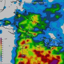
The Tropical Rainfall Measuring Mission (TRMM) satellite had a partial view of hurricane Sandy on Oct. 25 at 1425 UTC (10:25 a.m. EDT) after it had passed over Cuba and moved into the Bahamas. An eye was hard to find but TRMM’s Microwave Imager (TMI) data showed that a large area of intense rainfall was occurring around Sandy’s center of circulation. Hal Pierce of NASA’s TRMM Team at NASA’s Goddard Space Flight Center in Greenbelt, Md. used a GOES-13 satellite image captured at the same time to fill in the part of the image not viewed by TRMM to create a total picture of the storm.
With its combination of passive microwave and active radar sensors, TRMM is ideally suited to measure rainfall from space. For increased coverage, TRMM can be used to calibrate rainfall estimates from other additional satellites. The TRMM-based, near-real time Multi-satellite Precipitation Analysis (TMPA) made at NASA Goddard can be used to rainfall over a wide portion of the globe. TMPA rainfall totals were tallied for the seven-day period from Oct. 18-25, 2012.
“Models are coming into consensus on a landfall, if you will, in the DelMarVa area. Comparisons are being made to the Perfect Storm of 1991, but many folks won’t remember that. Storm will bring very strong winds (hurricane force) over a strong area. Remember the Derecho of June 29, 2012. Expand that to the entire Delaware/Maryland/Virginia and New York/New Jersey region,” Shepherd said when asked about the expected effects of the storm.
Referring to the amazing amount of data coming in from the TRIMM satellite analysis as well as numerous other satellites, Doppler, microwave, thermal, and otherwise have been watching the storm move up the Atlantic towards the East Coast. National weather service modeling must take into account data from numerous sources all at once—numerous elements of which involve NASA’s infrastructure, aircraft, satellites, and their ilk. Together the take up a lot of processing power.
Only recently, Big Data outfits went to work to determine how to best direct emergency responders and inform evacuees during Hurricane Isaac; computer scientists at Rice University set up a model that would assist with supercomputers and Big Data and it went to helping New Orleans prepare. Only months earlier the NSF put a push in to add more Big Data cyberinfrastructure to Federal and local sciences for predicting, preparing, and modeling hurricane disaster events.
The Bride of Frakenstorm Bringing a Dismal Halloween to the East Coast
According to current models built up by the confluence of NASA’s data and national weather service data, Hurricane Sandy is going to run into a cold Arctic air mass, lending it to become the “Bride of Frakenstorm.” Knowing this sets up the models needed to prepare the East Coast states that will be most affected by whatever happens when the hurricane finally makes landfall.
With each passing day, that model will become more accurate; but having better information sooner (provided by more data and real time processing compared to historical models) will give everyone working to prepare for the hurricane event and aftermath a better idea of what districts to focus on and where to set up.
Striking that cold air mass sees a model of Hurricane Sandy expanding with hurricane force winds extending outward up to 35 miles from the center with tropical storm winds extending out to 275 miles. The storm’s effects are expected to start to be felt as early as Sunday, Oct 28. Right now seems like the best time to predict its landfall position, make as good guesses as possible about the winds and storm surge, and start putting emergency responders in position to remain mobile when the wind starts.
Good luck East Coast; and may the Big Data and the science provide weather proofing to your states.
THANK YOU