


 NEWS
NEWS
NEWS
NEWS
NEWS
Computer vision startup Placemeter Inc. launched a new set of tools today that could change the way cities are built, affecting everything from where crosswalks are placed to the locations businesses choose to set up shop.
Placemeter’s “urban intelligence platform” uses computer vision to extract data from video of public places, tracking the movement patterns of pedestrian and vehicle traffic. Watching people walking down the sidewalk may not sound exciting, but the knowledge that can be gained from measuring public movement can offer profound insights into the daily life of a city and its residents.
“We need to optimize the way cities work, but to do that, we need to measure and quantify the way people use our physical world,” Placemeter CEO Alex Winter said. “Measuring what people actually do is important.”
Winter said that a few location-tracking services already exist, but most rely on Wi-Fi pinging, which is not only inaccurate but could also be a violation of privacy. There is also the possibility of using satellite imagery to look at information such as the number of cars in a parking lot, but this technology is unable to track locations in finer detail and it cannot be used on-demand 24/7.
Placemeter avoids the privacy dilemma by not tracking any identifiable information like biometrics or gait, and it does not actually store the videos it measures. Winter said that if anyone looked at Placemeter’s data, they would only see “counts and statistics.”
The goal for Placemeter, according to Winter, is to make an intelligence platform that is not only easy to use, but can also measure movement patterns accurately over a significant length of time.
“At Placemeter, we believe that computer vision and video is the only viable, scalable solution to do that,” Winter said, “which is why we’ve built an urban intelligence platform to quantify the movement of modern cities, at scale.”
Users can upload recorded video to Placemeter, or they can connect to a live camera through an IP address. Placemeter will also soon offer its own sensors, which are inconspicuous cameras specifically designed to track traffic patterns outside of a location.
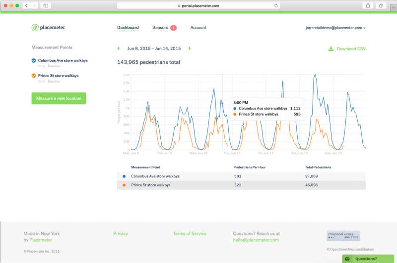
The platform has its own dashboard that shows the way traffic at a location changes over time, showing the spikes and dips in activity. It is also capable of measuring the data more granularly, distinguishing between where people are walking, in what direction they are moving, and more.
Winter noted that during its two-year private beta, Placemeter saw testers with several use cases for its technology.
For example, one business was able to use Placemeter to compare two locations to see where it should open a new store. Both potential locations were in Union Square in New York City, and while one spot had a higher total volume of foot traffic, Placemeter was able to show that most of that traffic was made up of commuters who were less likely to be in the mood to shop.
The other location, however, saw more off-hour foot traffic, which meant that it had a better chance of drawing shoppers in, even if it saw fewer people walking by overall.
The data measured by Placemeter can be downloaded as a CSV file, allowing users to create their own data models by comparing movement patterns with other factors like weather, advertising campaigns, and so on.
Placemeter’s platform is now open to everyone at a rate of $99/month per measurement point for a 12-months plan, or at $149/month per measurement point with no commitment.
“I really believe that this is going to change the how people go about understanding the world,” Winter said. “Making this type of data more accessible and affordable, bringing that data to the world is something that’s really exciting, and we’re looking forward to see how people use it.”
Support our mission to keep content open and free by engaging with theCUBE community. Join theCUBE’s Alumni Trust Network, where technology leaders connect, share intelligence and create opportunities.
Founded by tech visionaries John Furrier and Dave Vellante, SiliconANGLE Media has built a dynamic ecosystem of industry-leading digital media brands that reach 15+ million elite tech professionals. Our new proprietary theCUBE AI Video Cloud is breaking ground in audience interaction, leveraging theCUBEai.com neural network to help technology companies make data-driven decisions and stay at the forefront of industry conversations.