


 BIG DATA
BIG DATA
BIG DATA
BIG DATA
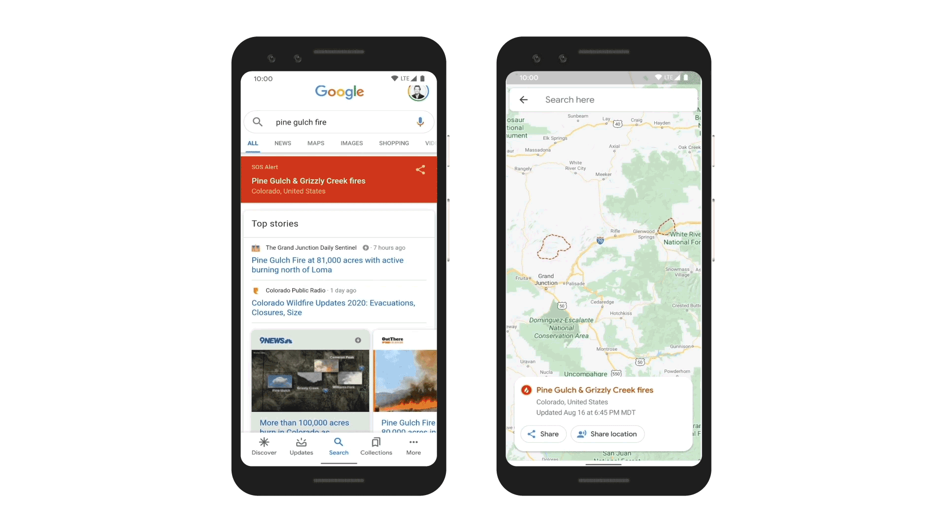
Google LLC said today it has updated its Maps and Search tools to show wildfire boundaries so people can see exactly where they’re located in real time and work out how to avoid them.
In addition, the Google search engine will also provide the latest news reports and helpful resources from local emergency services in its results.
Yossi Matias, Google’s vice president of engineering and crisis response lead, revealed the updates to Google’s SOS alerts in a blog post, saying that Maps is using satellite data from the National Oceanic and Atmospheric Administration’s GOES constellation alongside Google Earth Engine’s data analysis tools. That enables Google Maps to show the size of wildfires in “near real-time” and update them on an hourly basis.
Matias explained that NOAA’s satellites are ideal for that because they’re equipped with infrared and optical sensors that have been optimized to detect “hot spots” or large wildfires on the Earth’s surface.
“We run computations on this data in Earth Engine to identify the affected area,” he said. “From there, we create a digital polygon — the red boundary shown on the map in Search and Google Maps — that represents the approximate wildfire impact area. If multiple large fires are active in the same region, people may see several polygons.”
Now, when users search a term such as “wildfire in California” or something more specific such as “Kincade fire,” Google Search will reveal a map showing the approximate boundary of the fire, as well as details such as its name and location, and relevant news articles and resources from local emergency services. Google Maps will also warn users if they approach an active wildfire, with an ambient alert that points them to the latest information on the blaze.
Google said the new features were piloted in California to determine their effectiveness and will now roll out to the rest of the world.
The updates are timely, as heatwaves are currently sweeping across parts of the U.S., increasing the threat from wildfires. Firefighters have already responded to large blazes in Northern and Southern California and in other states, such as Colorado. Matias said that by providing more up-to-date information, it hopes it can save lives in affected regions.
Constellation Research Inc. analyst Holger Mueller told SiliconANGLE it’s always good to see companies like Google using their technology for the greater good. He said today’s update is a good example of how data sources can be combined to deliver better insights and maybe even save lives.
“Wildfire season in California is only just about to start, so we will see in a few weeks how well this new mapping technology works,” Mueller said.
The addition of real-time wildfire data in Google Maps is just the latest initiative by the company to combat natural disasters. Earlier this month, the company detailed a plan to use Android devices to detect earthquakes.
Support our mission to keep content open and free by engaging with theCUBE community. Join theCUBE’s Alumni Trust Network, where technology leaders connect, share intelligence and create opportunities.
Founded by tech visionaries John Furrier and Dave Vellante, SiliconANGLE Media has built a dynamic ecosystem of industry-leading digital media brands that reach 15+ million elite tech professionals. Our new proprietary theCUBE AI Video Cloud is breaking ground in audience interaction, leveraging theCUBEai.com neural network to help technology companies make data-driven decisions and stay at the forefront of industry conversations.