


 BIG DATA
BIG DATA
BIG DATA
BIG DATA
There’s more to business intelligence than just raw numbers for retailers and other enterprises that have a large physical footprint. Data such as sales performance have to be put in a geographic context to be meaningful, which is what Boundless Spatial Inc. hopes to enable with its latest product.
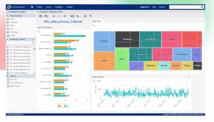
The five-year-old startup today unveiled a platform called Boundless Enterprise that’s designed to facilitate geospatial analysis on a large scale. It’s a cloud-based incarnation of the provider’s existing Boundless Standard offering. The software, which is used by big names such as Thomson Reuters Corp and Hitachi Ltd., has been retooled to let firms process their location data in a more efficient way.
Boundless said the platform can turn raw geospatial records into a multilayer map to visualize operational patterns. A logistics company, for example, might create a high-level view of its delivery routes to help analysts find ways to shorten shipping times. A retailer could overlay consumer spending and competitor data on a similar map to identify areas that present expansion opportunities.
According to Boundless, the platform can support as many as millions of map layers for projects that require a fine-grained view. It provides the ability to add or reduce the amount of hardware resources in a deployment as usage changes, which the startup said is particularly handy for dealing with sudden activity spikes.
There’s also a failover tool for handling potential outages. The feature is meant to remove the need for a company to implement reliability features manually in the cloud environment where it runs the software, a task that can take awhile when there’s a lot of infrastructure involved.
Boundless Enterprise supports Amazon Web Services Inc.’s and Microsoft Corp.’s Azure clouds on launch. The platform also comes in a containerized edition that works with environments powered by Kubernetes, the popular container orchestration framework for enabling applications to run in multiple computer environments.
Boundless operates in a crowded area. There are numerous other software providers focused on helping companies extract value from their geospatial records, each with its own approach. Nvidia Corp.-backed MapD Technologies Inc., for example, uses graphics processing unit chips to enable rapid map rendering.
Support our mission to keep content open and free by engaging with theCUBE community. Join theCUBE’s Alumni Trust Network, where technology leaders connect, share intelligence and create opportunities.
Founded by tech visionaries John Furrier and Dave Vellante, SiliconANGLE Media has built a dynamic ecosystem of industry-leading digital media brands that reach 15+ million elite tech professionals. Our new proprietary theCUBE AI Video Cloud is breaking ground in audience interaction, leveraging theCUBEai.com neural network to help technology companies make data-driven decisions and stay at the forefront of industry conversations.