


 EMERGING TECH
EMERGING TECH
EMERGING TECH
EMERGING TECH
Yahoo! Japan today announced the release of augmented reality navigation for the company’s mapping application for iOS phones and mobile devices.
The addition to Yahoo! Japan Maps will provide users an “in-world” visualization of the route to their destination using the phone’s camera. The new feature uses the ARKit framework available with iOS 11 and will overlay visuals on the actual landscape in three dimensions along with path markers and confirmation of direction and distance with augmented reality road signs.
According to a statement from the company, this feature will be experimentally available starting today for app users in Japan. Details are available at Yahoo! Japan (in Japanese) explaining the use of the app and what it can do.
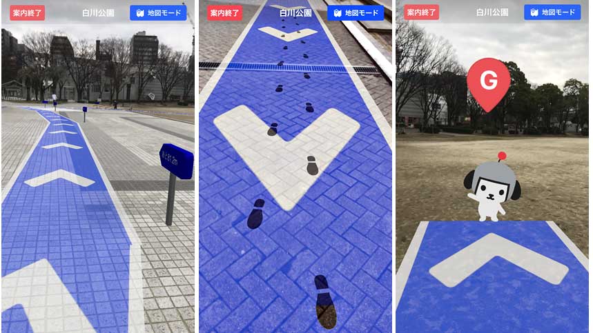
Users can access the “AR mode” in Yahoo! Maps by searching for a walking route to a destination and then pressing the “AR mode” button on the upper right-hand side of the screen. This will switch on the phone’s camera and turn the device essentially into a “window” into the augmented reality.
Once in “AR mode” the user then will see a path projected onto the visible landscape. The path is displayed as a blue ribbon that follows the ground. White arrows indicate the direction of travel.
Additionally, 3-D “road signs” will appear periodically besides the path in the form of a signpost and arrow that lists the distance remaining to the destination. This way, as the user walks the path, they’ll get a sense of progress towards the goal.
To amuse users and help give them an idea of how far they have traversed, users can also turn on a “footprints” function. This will add images of shoe prints, footprints or dog pawprints along the route already walked.
Finally, at the end of the route, the users will find a friendly mascot of Yahoo! Japan named Kenshuku standing at the destination waving her hand. Kenshuku is a small, white dog wearing a helmet with a red dot attached to the top.
Although the app is extremely useful for providing a highly visual and interactive way to guide people to a destination, it is far more distracting than a voice or a map with a route. As a result, app users receive a warning that they should also pay attention to the world around them while using “AR mode” because the phone screen will tend to limit visibility and potentially put pedestrians in danger.
“Walking while looking at the screen of the smartphone is very dangerous. Please be sure to stop and use,” a disclaimer on the app will read. “Route lines different from the actual may be displayed depending on the situation of GPS and various sensors.”
The “AR mode” is also energy-hungry and users will be warned to check their battery level before using it. To activate and use AR the phone must constantly operate the camera, GPS and network at the same time, this could quickly drain even the most efficient phone’s battery.
Very few AR apps have come to market using the technology to enhance navigation, but with the launch of development platforms ARKit from Apple Inc. and ARCore from Google LLC, they have been a growing trend in the GPS app industry. In July, Blippar launched an AR navigation app for iOS and Android that operates similarly called AR City. A month earlier, Sygic integrated AR into its mobile vehicular GPS system using ARKit.
And, in March 2017, Chinese e-commerce company Alibaba Group Holding Ltd. invested $17 million in WayRay SA, another startup working on vehicular navigation that projects an image onto the inside of the windshield as to avoid distracting the driver unnecessarily.
Major mapping and navigation features of popular apps do not yet support AR modes, making the experiment by Yahoo! Japan a stepping stone to understanding how the industry might grow in the future.
That this feature is being bought by Yahoo! to users in Japan also brings some attention to the industry. Although Google is popular in Western states, Yahoo! is extremely popular in Japan, according to an Oxford Internet Institute study from 2013. Although it is possible for developers to link Google Maps to AR apps, the company itself has not come forward with any navigation integrations yet of its own.
THANK YOU