


 No matter if it’s Black Death in 1350, the Spanish Flu of 1918-19, or this year’s Ebola virus in West Africa, there’s one thing that deadly pandemics have in common – their progress takes a geographical course.
And just as in medieval times, the Ebola virus’ rampage across Guinea, Liberia and Sierra Leone is fueled by a lack of understanding about the disease, including the way it’s transmitted from one person to another. But unlike with Black Death all those centuries ago, those leading the fight against Ebola can rely on the very best mapping technology to try and halt its spread.
Mapping Ebola has suddenly become in vogue. Reuters reports that scientists from Oxford and University of Southampton in Britain, Canada’s University of Toronto, and HealthMap at Boston Children’s Hospital in the United States, have just created a new map highlighting those areas most at risk of an Ebola outbreak, and it’s not a pretty picture. The map shows that regions populated by animals thought to host the virus (such as fruit bats) are far more widespread than first thought, especially in West Africa.
Ebola, which can kill up to 90 percent of those it infects, usually infects humans when they come into contact with animals carrying the disease. When a virus jumps from animal to human it’s known as a “zoonotic event”, and is believed to be the cause of the first cases of HIV and H1NI swine flu in humans. And while doctors currently battling Ebola are more worried about human to human transmission, the new map shows the deadly potential for new outbreaks – large swathes of western and central Africa fall within the “zoonotic niche” for Ebola.
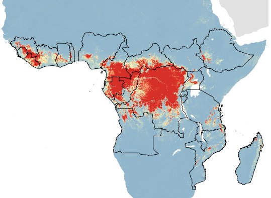
Map illustrating regions where Ebola could potentially ‘jump’ from animals to humans
The scientists didn’t attempt to map possible human-to-human transmissions, but there are others who have already done so. Indeed, the HealthMap organization actually spotted a “mystery hemorrhagic fever” nine days before the World Health Organization declared the current Ebola epidemic, though at the time it didn’t realize what it had discovered. HealthMap uses software that mines government websites, local news reports, social media and other sources to map deadly outbreaks and monitore them in real-time.
Eight people reported the mysterious disease in March, but although it caught the HealthMap team’s attention, but they didn’t call out a massive issue until it was confirmed as Ebola on March 22. Since then, they’ve created a dedicated visualization at healthmap.org/ebola. The tool shows the full timeline of events, including locations, case counts (suspected, confirmed, deaths), and original source documentation.
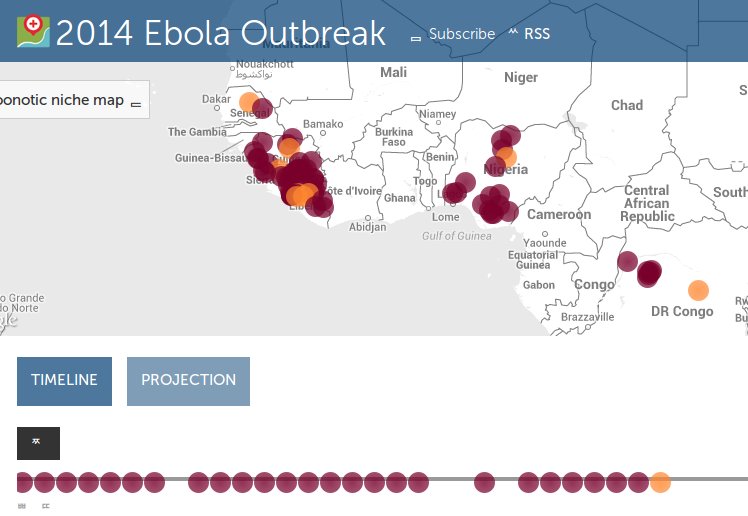
The early warning “shows some of these informal sources are helping paint a picture of what’s happening that’s useful to these public health agencies,” HealthMap cofounder John Brownstein, a computational epidemiologist, told the Associated Press.
Potentially even more useful is the following visualization of the outbreak from Swedish nonprofit group Flowminder, which was created using data from over 150,000 mobile phone users in Senegal. The visualization goes a step further than HealthMap, as it actually tries to predict how travel might spread Ebola in the weeks and months ahead.
“If there are outbreaks in other countries, this might tell what places connected to the outbreak location might be at increased risk of new outbreaks,” Flowminder cofounder and Executive Director Linus Bengtsson told MIT Technology Review.
But the idea is not to restrict people’s movements – something the WHO has advised against, and has criticized Sierra Leone’s government for doing. Rather, the creators simply want to provide clues as to where preventative efforts should be focused.
Mapping technologies such as these could prove to be instrumental in helping responders get a grip on the outbreak, noted Kathryn Jacobsen of George Mason University in Virginia, in an open letter to The Lancet last month:
“Infectious disease surveillance systems should be strengthened by adopting new data-sharing technologies,” she wrote. “Emerging technologies can help early warning systems, outbreak response, and communication between health-care providers, wildlife and veterinary professionals, local and national health authorities, and international health agencies.
Support our mission to keep content open and free by engaging with theCUBE community. Join theCUBE’s Alumni Trust Network, where technology leaders connect, share intelligence and create opportunities.
Founded by tech visionaries John Furrier and Dave Vellante, SiliconANGLE Media has built a dynamic ecosystem of industry-leading digital media brands that reach 15+ million elite tech professionals. Our new proprietary theCUBE AI Video Cloud is breaking ground in audience interaction, leveraging theCUBEai.com neural network to help technology companies make data-driven decisions and stay at the forefront of industry conversations.