


 NEWS
NEWS
NEWS
NEWS
NEWS
 With Hurricane Sandy on a collision course with the United State’s eastern seaboard this morning, Google has just launched a dedicated crisis map to assist those affected by the storm.
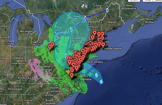
The Hurricane Sandy crisis map will track the path of the storm as it smashes into the mid-Atlantic coast later today. It provides several layers of information, including the storms’ projected path (which currently shows the eye of the storm bearing down on New Jersey), locations of shelters, public alerts, cloud imagery and more.
In addition, Google has produced a more detailed map for those living in New York City itself, which residents can use to find the nearest evacuation center or Red Cross emergency shelter.
Fox News reports that Hurricane Sandy is currently rated as a ‘category 1’ storm, blowing sustained gusts of winds at 85mph. At 08.00 EDT, the storm was about 310 miles southeast of New York, heading north-west at roughly 14mph, with hurricane force winds said to be extending an awesome 175 miles from its center. The National Hurricane Center latest advice warns that Hurricane Sandy has gathered strength over the last few hours, and could bring with it a “life threatening” storm surge.

Support our mission to keep content open and free by engaging with theCUBE community. Join theCUBE’s Alumni Trust Network, where technology leaders connect, share intelligence and create opportunities.
Founded by tech visionaries John Furrier and Dave Vellante, SiliconANGLE Media has built a dynamic ecosystem of industry-leading digital media brands that reach 15+ million elite tech professionals. Our new proprietary theCUBE AI Video Cloud is breaking ground in audience interaction, leveraging theCUBEai.com neural network to help technology companies make data-driven decisions and stay at the forefront of industry conversations.